The cliffnotes
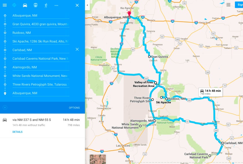
Summary: Carlsbad Caverns National Park is the only national park in the state of New Mexico. It is in the far southeast part of the state so a visit requires some travel time. The fastest route from Albuquerque is 4½ hours, but features fewer tourist attractions. On this trip, we went through the Sacramento Mountains at Ruidoso (east) and Cloudcroft (west). This let us visit Ski Apache in Ruidoso and White Sands National Monument in Alamogordo. We left after lunch on Thursday, and returned home around 5 on Sunday.
The unexpected good: Ruidoso was great! It’s like a little Colorado resort in southern New Mexico. We loved our lodging and the food. The Three Rivers Petroglyph Site near Tularosa had vivid petroglyphs with stunning backdrops. And the weather in late February was a great balance; the ski resort got some snow shortly before our arrival, the Tularosa Basin wasn’t too hot or cold, and road quality was good.
The bad: 15 hours of driving in four days was a lot, even on the easy roads of New Mexico. Ideally, we would have stayed another night in Carlsbad but (1) the hotels are pricy, and (2) the elevators at the national park are offline until summer 2016. Going up and down the natural route was too tiring to do more than once. Lastly, the drive from Artesia to Cloudcroft at sunset was beautiful but not very fun. We had too many close calls with deer. They are on the move at sunset, and the driver is blinded by the sun going west.
Places visited (click the links to jump to the sections)
Duration: 3 nights, 15 hours total driving time
- Night 1; Thursday, February 25th: The Sitzmark Chalet Inn in Ruidoso, NM
- Night 2; Friday, February 26th: Carlsbad, NM
- Night 3; Saturday, February 27th: Alamogordo, NM
The route
Click here for the interactive Google map with the above destinations to make your own changes!
Salinas Pueblo Missions National Monument—Gran Quivira Ruins
Salinas Pueblo Missions are a different kind of ruins than Chaco Canyon or Mesa Verde—they are the ruins of both ancient native life and the intersection of that life with Europe in the 1600s. The Salinas Pueblo Missions National Monument contains sites of three Franciscan missions on the New Mexican frontier. These sites were abandoned in the late 1600s and weren’t rediscovered again until the 1800s; they are artifacts of ancient native life, the Catholic effort to convert the Pueblo, and interactions of the New Mexican government, the Catholic presence, and the Pueblo Indians. Gran Quivira has been a national monument since 1909.
As you may have guessed, ruins that the world forgot for 150 years are fairly remote. The Gran Quivira Ruins are an hour and a half from Albuquerque, beyond the Manzano Mountains. But if you’re heading to Ruidoso, the visit adds only half an hour.
Gran Quivira is a stark place. There are no trees, and you can see for miles. We were there at midday, and you can see from the photos below that the light is harsh. I suspect summer at Gran Quivira would be oppressive.
In the ruins, I felt that I stood at the memorial to a tragic intersection. The park ranger told us that local Indians still consider the site sacred, and visit from time to time. The remains of a village and kivas, Pueblo religious structures, sit side-by-side with two large Franciscan churches. The village contains several hidden kivas as well; as the Franciscans stayed longer, they grew less tolerant of the native practices. The title of this excellent (but long) report on the site says a lot: “In the Midst of a Loneliness.” Gran Quivira, remnant of contact between two worlds, is very, very lonely.
This slideshow requires JavaScript.
Return to top
Ski Apache near Ruidoso
I am a rookie skier, but I’m trying to learn since New Mexico has such wonderful mountains. We stayed in Ruidoso and went skiing at Ski Apache in the morning. The drive was slow and winding but what views! Ski Apache is on the second highest peak of the Sacramento Mountains, next to the highest peak, Sierra Blanca. We got to be good friends of Sierra Blanca by the end of our trip. We took the gondola to the top of the mountain to look west. From the top of Ski Apache we saw White Sands National Monument and the black lava of Valley of Fires.
Though we were in Ruidoso for less than 24 hours, I was charmed and I want to go back. Our hotel, the Sitzmark Chalet Inn, was an adorable and affordable little ski chalet complete with a fireplace. We had an awesome meal at Grill Caliente (amongst other things, their salsa was delicious). When it gets hot in Albuquerque, I will remember Ruidoso.
This slideshow requires JavaScript.
Return to top
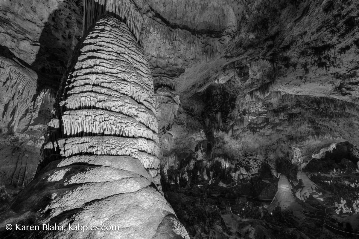
Carlsbad Caverns National Park
The main feature of the trip! Alas, the elevator was broken, which added over a mile each way to our journey. I was happy on the way down, but less excited when it was time to climb. I was carrying many pounds of camera equipment, and grateful for the subterranean climate. The elevators should be repaired by summer, from what we were told.
The caves are awesome. Of course they were. We spent a whole day in the caves, and I want to go back already. Parts of the cave close at 3:30, so with the elevators offline, it’s important to start early. There are guided tours to additional areas. They don’t allow tripods, so I didn’t get to see them this trip.
I gained an appreciation for the fragility of the cave ecosystem. As we descended the trail, dozens of boy scouts lay on the floor, dabbing it with paint brushes. They were removing lint—the hair, skin cells, and other debris we leave as we go about our business, but is bad for a cave’s health. You also can’t bring food into the cave for this reason. We walked the asphalt path from the entrance and through the great room. I imagined what damage that must have caused to the environment and what a cave expert might tell me. But what’s done is done, and I was very happy to explore this subterranean wonder.
We had little time to explore Carlsbad. But it’s nearly in Texas, and that inspired thoughts of barbecue. We went to Red Chimney Bar-B-Que and had some awesome brisket. Even on a busy Friday night, we ate well and quickly. Pecans are a local crop in the southeastern part of the state, so I got some pecan pie to go and had it from breakfast in the morning.
This slideshow requires JavaScript.
Return to top
White Sands National Monument
I first visited White Sands in the fall; I loved it so much I wanted to visit again on this trip. That meant driving from Artesia through Cloudcroft to Alamogordo. It was a beautiful drive, but on the east side of the range we saw more deer than cars. We drove west at sunset and dusk, which in retrospect wasn’t a good idea.
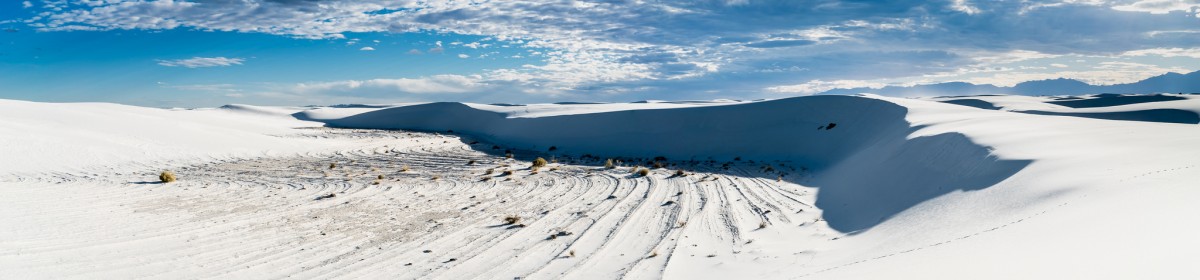
I recently moved west, and White Sands is delightfully western to me. It’s a national monument nestled into a missile range. Sometimes it’s closed when they are testing missiles! The whole thing is made of gypsum, the same stuff that makes drywall. Gypsum dunes aren’t very common because gypsum is soluble. But the Tularosa Basin that hold White Sands, Three Rivers petroglyphs, and Valley of Fires is nearly devoid of water. So it has dunes of gypsum that are so snow white they stay cool under the hottest sun. In the visitor’s center, you can buy sleds and slide down the dunes like snow too. (The air doesn’t stay cool, so visitors should bring lots of water. There is no water within the park. We have a 5 gallon jug we leave in the car on every trip in case of emergencies. It’s less than $20 on Amazon.)
White Sands is like visiting an alien world. NASA tests Mars equipment at White Sands. The dunes at White Sands have been used to model the gypsum dunes on Mars. At White Sands, you walk in whiteness between two mountain ranges. Despite the austerity, signs of life are everywhere. There are roadrunner tracks, beetle tracks, and more. During the day, though, you see little but the remnants.
This slideshow requires JavaScript.
Return to top
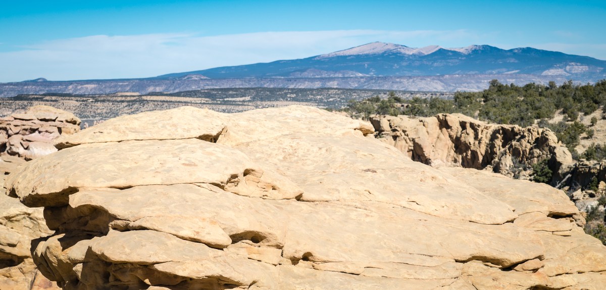
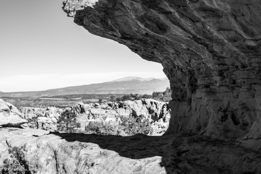
Three Rivers Petroglyph Site
After a few hours at White Sands, wind blew up some dust and haze. We left early and looked online for some other attractions along our route. We found the Bureau of Land Management’s Three Rivers Petroglyph Site. Since Albuquerque has wonderful petroglyph in Petroglyphs National Monument, we wondered if it would be worth it, but the reviews were encouraging.
Three Rivers is just north of Tularosa, so we stopped in at the Casa de Sueños restaurant. They are fast, cheap, and delicious. It was our second visit, every bit as good as the first one. On weekdays, they have a nice lunch buffet.
Three Rivers Petroglyph Site was definitely worth it. It’s only a paved mile or two off US 54. As with White Sands, the San Andres Mountains in the west and the Sacramento Mountains in the east provide dramatic backdrops. With a National Parks Pass, Three Rivers is free, and without it, it’s still cheap. It even has RV hookups and plumbed bathrooms. Three Rivers has 21,000 petroglyphs, and you enjoy them under Ski Apache’s Sierra Blanca. Albuquerque’s petroglyphs provide an interesting juxtaposition between city and ancient. Three River’s petroglyphs seem at home in the untamed west.
This slideshow requires JavaScript.
Return to top
Valley of Fires
We weren’t done yet with the Tularosa Basin. Next was the Valley of Fires, a long patch of lava just west of Carrizozo. Carrizozo is the county seat of Lincoln County, which may sound familiar if you are a western enthusiast. Billy the Kid is the famous outlaw of the Lincoln County War. The area is littered with historical markers for murders and battles associated with the war. Carrizozo was also the first town downwind of the Trinity nuclear test.
Valley of Fires is a lava flow north of White Sands. What a strange valley the Tularosa Basin is—stark white in the south, black in the north,containing a missile testing site and rimmed by mountains and nearly devoid of water. The Valley of Fires flow is the second youngest lava site in the state, second to the El Malpais National Monument flow. It has a maintained walking path, which is nice because lava is tough to walk on. To the west, we got one more beautiful view of Sierra Blanca. The recreation area has toilets and picnic areas and more RV hookups. Be aware that a parks’ pass only halves admission.
We drove west out of the Tularosa Basin and past the turnoff for the Trinity Testing Site, which is only open one day a year (April 2, 2016, this year). The testing site is in the Jornada del Muerto (trans: route of the dead man) desert in the western part of the White Sands Missile Range. Then we were back in the Rio Grande Valley, and our vacation was over.
This slideshow requires JavaScript.
Return to top
The Grand Recap
We crossed the Sacramento Mountains to and from Carlsbad Caverns. For a four day trip, this added more driving than ideal; it would have been better to go the quick route one way and only meander for one leg. The drive from Carlsbad to Alamogordo was especially challenging and should not be done at sunset.
But everything we visited was awesome. The weather in late winter was comfortable for hiking, let us ski, and let us enjoy snowy vistas of Sierra Blanca. There is a lot to do in the southeastern part of the state, and we just skimmed the surface on this trip.

